Part I: Noughaval
Caherkyletaan; Cahercuttine
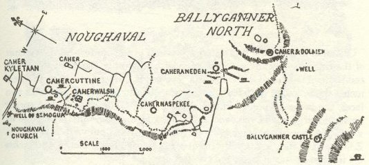
Along the desolate ridges between Noughaval and Ballyganner lie a group of forts so numerous and implying so much labour that we may conclude that an actual city and considerable population occupied this lonely site. [1]
‘Their raths are not dwelt in -
Their ancient cathairs -
Whereon great duration was wrought -
They are waste . . . like Lugaid’s House.’ [2]
Plan of Noughaval and Ballyganner
Six ‘forts’ and two cromlechs run in line nearly N. and S. towards the summit of Ballyganner hill. From Cahernaspekee, and the last of these, five more lie eastward with four cromlechs. Small ‘caves,’ cairns, circles, and hut-sites abound; and near the N. end are the venerable church of Noughaval [3] with two crosses, the ‘O’Davoren’s chapel’ and the well of St. Mogua with its uncouth and ancient ash tree.
At the south end are the huge cromlech, castle, and three cahers of Ballyganner. The ridge has a wide view over Kilfenora, while Liscannor Bay is visible through a gap in the hills, from the gate of Cahercuttine. The whole site abounds in beautiful crag flowers.
Caherkyletaan (105 feet x 120 feet).
A straight-sided fort, walls 4 feet or 5 feet high and 10 feet thick,
of large slabs; it has a cross wall and some prostrate pillar stones,
but no trace of a gateway.

Cahercuttine – Fort and Cromlech, from south
Cahercuttine (137 ft. x 130 ft.).
A well preserved fort on the summit of the ridge, commanding a view of
most of the other cahers of the group and those of Doon and Ballykinvarga.
Its wall is 11 feet 4 inches to 12 feet 6 inches thick, and up to 10
feet high, very well built, of large stones, with two faces, the inner
having a plinth 9 inches wide. [4] The gateway had corner posts and large
lintels, removed to admit cattle, the main lintel was 8 ft. 6 in. x
2 ft. x 1 foot; the passage, 5 ft. 8 in. within, widens outward: it
faces S. S. E. [5] ; near it to the west is a fine flight of six steps,
3 feet 9 inches x 10 inches x 4 inches to 6 inches tread and two feet
deep.
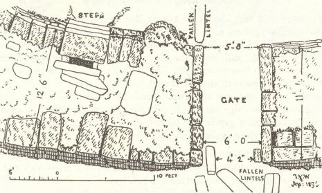
Plan of Entrance, Cahercuttine
This fort is a veritable garden of ferns, harebells, and cranesbills. In the field to the west are a small cromlech 8 ft. x 6 ft., a ring wall of large slabs 24 feet diameter, with walls 3 feet 6 inches thick, and a miniature souterrain. Two flights of five and four steps remain nearly hidden by grass and weeds to the E.S.E. and N.W. by N. They are similar to the third southern flight, and lead upwards from the plinth or narrow platform.

Steps and Gate, Cahercuttine
A cairn, [6] semicircle, and pile of large blocks occur in the same field, while south of the fort are another cairn and an overthrown cromlech 7 feet x 12 feet. A small oval fort stands about 200 yards to the east. It is featureless and defaced, with coarse walls 9 feet thick, and an enclosure about 85 feet long, tapering to the south. [7]